Thailand’s north-eastern region, widely known as Isan, is a well defined geographical area. The origin of the topographical name of Isan lies in the cosmology of Hinduism. The proper noun “Isan” is a variant of the word “Isuan”, which itself is derived from the Sanskrit name of Shiva, Iswara. The logical link between the name of the Hindu deity, known as Shiva or Iswara, and the vernacular name of Thailand’s north-eastern region, Isan, is embedded in the Hindu cosmology, where Shiva is the regent of the northeastern quarter of the world.
The area size of Isan equals almost exactly one third of Thailand, with as large a proportion of its population. In comparison by area size, the region called Isan almost equals the area size of Uruguay. Isan is slightly larger than the countries of Tunisia or Surinam, and considerably larger than Nepal, Bangladesh, or England.
In terms of physical geography, the Isan, the northeastern region, is also known as the Khorat Plateau. It is flanked, in the west, by the Phetchabun Mountain Range and the Phang Hoei Mountain Range, in the southwest by the San Kamphaeng Mountain Range, and in the south by the Dong Rak Mountain Range. Straddling the northeastern interior is the Phu Phan Mountain Range, which separates two wide basins of low-lying lands, Khorat Basin in the southwest and Sakon Nakhon Basin in the northeast.
High mountains in the west and south as well as the interior mountain range with the headwater areas of the Mun and Chi rivers as well as numerous minor tributaries of the Mekong River in the northwest and northeast define three river basins, namely, Mun River, Chi River, and Mekong minor tributary river basins, in descending order of magnitude. The Khorat Basin encompasses two vast plains, one in its western part called Thung Samrit and another in its eastern part named Thung KulaRong Hai. These plains, called thung in Thai, serve as overflow areas during the rainy season. In the dry season, they are parched and bare of anything but coarse grass. Hence, they are large semi-arid expanses dotted with natural levees or ridges which are one to five metres higher than the surrounding area. While the plains are subject to regular inundation, the levees or ridges are not normally flooded. Above these levels are the alluvial and bedrock terraces. It is in these locations where the human habitat evolved throughout history. Similar are the physical conditions in the Songkhram River Basin with its seasonal marshes along the rivers [bung in the local Thai vernacular] and its low-lying wetlands [tham in the local Thai vernacular], both naturally grown with flood-plain forests.
As the bedrock of the Khorat Plateau, by which name geologists refer to the entire northeastern region, consists of cetaceous rocks such as sandstone, shale and siltstone, with considerable layers of rock salt and other salt-bearing strata, water supply has always been precarious. In short, Isan is sitting on one of the world’s largest rock salt stocks. It is for this reason that surface water collection has been vital. Reservoirs of small or medium sizes have been built and operated in elevated terrain, since historical times and until this day.
The heartland of Isan, Thailand’s northeastern region, is on elevated ground where fresh water is available and flooding does not normally occur. The natural environment on hills and mountains provides resources which supplement people’s productive activities and help to secure their livelihood. One of the natural resources, vegetation cover, especially forests, has been largely depleted in the course of history. Timber was in increasing demand for construction, including scaffolding in the process of erecting magnificent laterite and stone edifices as well as steadying structures not built of laterite or stone. Lumber and crooked wood, or knee-wood, was needed as fuel-wood, the sole source of energy for all activities that required thermal processing, notably operating innumerable kilns.
Another natural resource, rock salt, was of vital importance for survival, through direct intake by human beings and animals alike. Over the centuries, salt was the sole means for the preservation and storage of food stuff fit for human consumption. Salt was a vital necessity and valuable commodity. To sum up, the concurrent availability of forests in headwater areas, of game owing to rich wildlife, of reliable fresh water supply, of building materials such as timber, laterite, sandstone and clay, of alluvial soil in depressions suitable for crop cultivation, combined with flood protection and some measure of security in an elevated terrain made that area the preferred habitat. It covers the upland parts of the present provinces of Kalasin, Maha Sarakham, Roi Et, Sakon Nakhon and Yasothon, hence paraphrased the heartland of Isan.
PREHISTORY
The significance of living on higher ground is proven by evidence of life as long ago as when dinosaurs were roaming the uplands in the middle of the Khorat Plateau, in the area paraphrased the Heartland of Isan. In present-day Kalasin Province are three sites of big concentrations of dinosaur fossils and, indeed, some of the world’s major dinosaur fossil sites. They render evidence of two types, herbivorous and carnivorous dinosaurs, which lived between 265 and 130 million years ago. Most are fossils of sauropods, monsters with long necks and tails, which lived 150 - 130 million years ago. The remains of one particular sauropod render one of the most complete dinosaur skeletons ever found. Also, the skeleton of a carnivorous dinosaur of the Siamotyrannusisanensis species is considered one of the world’s greatest finds. Similarly spectacular discoveries were made at the site of Mueang Fa Daet Song Yang, capital of an ancient realm of the Dvaravati Period, now located in Kalasin Province. There, excavations also yielded evidence of an earlier settlement in prehistoric times, especially artefacts made from fired clay and bronze. They suggest that the Bronze Age had begun in this area before anywhere else in the world.
In 1987, people of Sakon Nakhon Province stalking game in the mountains named Phu Pha Yon discovered stone carvings at the sites of two caves. In front of the Phra Dan Raeng Cave, they found a 115 square metre-sized slab believed to have fallen off the cliff. Although damaged, the remains show images created by abrading and engraving. They are categorized as marks and symbols, geometric patterns, human body parts, animals including two fish, trees and boughs. Stone carvings found in a niche in the sandstone cliff at Pha Lai Cave are grouped as human beings, some lifelike, some semi-lifelike; animals, including a fish, dogs, a squirrel, buffaloes, cattle and frogs; geometric patterns; tools and utensils including a plough, a hoe and a fan; and two houses with a triangulated roof each. These stone carvings are deemed as of tremendous archaeological value. Some scholars surmise that these items of cave art are more than 3,500 years old, in all likelihood older than pre-historic symbolic images discovered in China and India. More of such prehistoric images were found at the Phak Nam Cave in the Phu Pha Lek and Huai Huat National Parks within Sakon Nakhon Province.
Further south, in Roi Et Province, at the Ban Dong Mueang Chok Archaeological Site, elevated by some five metres above its surroundings, water supply ditches and a rock salt pit as well as earthenware and pots containing human bone pieces indicate the existence of ancient communities. Their practice of a second burial suggests that this site was inhabited towards the end of prehistoric times, likely 2,500 years ago. As of now, salt is still extracted there for local consumption.
Ruins at the site of Dong Mueang Toei in the Kham Khuean Kaeo District of Yasothon Province indicate a whole sequence of cultural periods. The ruins show traces of a city that was originally built as a stronghold of the Chenla Empire, as early as in the 5th century.1 Named Sangkha Pura, it was laid out 450 metres wide and 650 metres long, surrounded by moats. Preserved are foundations of a palace and a Hindu sanctuary dedicated to the deity Shiva built of bricks, stone axes, and utensils.
MONUMENTS AND ARTEFACTS TRACED TO THE 6TH UNTIL 11TH CENTURIES : EXAMPLES OF THE DVARAVATI CULTURE
Indications are strong that the centre of power and culture in the heartland of Isan during the Dvaravati Period was the city known as Mueang Fa Daet Song Yang. Its ancient site, near the modern town of Kalasin, flourished during the 9th to 11th centuries. Within and around its perimeter which covers an area of 2.7 square kilometres and is laid out like a heart-shaped bai sema2or stela, ruins exist and traces have been found of 14 religious structures. Owing to the large number of baisema, artistically carved stelae, out of which more than 130 pieces are preserved, together with precious Buddha images, at the Khon Kaen National Museum, the ancient city of Mueang Fa Daet Song Yang is recognized as the largest and most important site of bai sema in the northeastern region of Thailand.
In the centre of this capital of a Dvaravati realm is the modest edifice of a monastery, Wat Pho Chai Semaram, which is surrounded by ancient sandstone stelae, bai sema, some of which are decorated with bas-relief. The finest was discovered in 1974. Its bas-relief shows a king and queen adoring the Buddha. The sheer number of stelae remaining insitu points to the wealth of artefacts coming from this ancient city surrounded by two rows of moats. The most complete ruin, also the tallest edifice of Mueang Fa Daet Song Yang, situated on a nearby hill, is Phra That Yakhu, a brick chedi, one of originally four pagodas built in the Dvaravati Period on the hills called Non Fa Yat and Non Fa Daet. Of the original pagoda only the star-shaped base decorated with some remaining traces of stucco has been preserved unchanged. During the Ayutthaya Period, an octagonal chedi was built on the original base, and during the Rattanakosin Period the top was raised.
It has been surmised that the indigenous population were Lawa, an ethnic group whose language belongs to the Mon-Khmer branch of Austro-Asiatic languages. Their settlements were located alongside the Lam Pao River. There, a small Buddha image carved from laterite was found which is now housed in Wat Klang. However, the name of the town and province, Kalasin, is Sanskrit in origin and translates as “black water”, a composite of “kala” meaning black and “sinthu” meaning water.
Historical monuments of the Dvaravati Period in Kalasin Province include the Phra Phutta Saiyat Phu Khao, a reclining Buddha image in the form of a bas-relief sculpted on a cliff. This image is believed to have been created about 2,000 years ago. It features the Buddha lying on the left instead of on the right side. Phuttha Sathan Phu Po is a religious site with two reclining Buddha images, with the larger one of the Dvaravati Period. This bas-relief image was sculpted on the cliff during the7th to 8th centuries. It was complemented by an Ayutthaya-style bas relief. Sheltered by an overhang in the cliff, both were gilded in the course of time. At close distance, another bas-relief of a reclining Buddha in the Dvaravati style, called Phra Phuttharup Choen Po, has likewise been gilded over during centuries of worshipping.
The monastery named Wat Si Bun Rueang, locally known as Wat Nuea, has kept some bai sema, originally from the ancient Dvaravati capital city of Mueang Fa Daet Song Yang. Most beautiful is the one depicting an angel flying above a castle, and a king and his family portrayed in the lower part.
At the site of the ancient city named Nakhon Champa Si in Maha Sarakham Province, the remains of an oval-shaped plan with walls and moats indicate its Dvaravati origin and existence during the 6th to 7th centuries, before it became an outpost of the Khmer Empire. Beginning in 1979, rings and plates made from bronze, and terra-cotta Buddha images were excavated at the site of an ancient stupa known as Phra That Na Dun. The rear sides of these Buddha images bear inscriptions, one 11.2 by 13.8 and the other 4.2 by 3.8 centimetres, both written in Pallawa letters used in the 6th to 7th centuries. Soon, villagers brought many more items such as stupa fragments and a compact containing relics of the Buddha. Eventually all led to the reconstruction of the religious edifice and its consecration in 1987.
Considered the most important Buddha images in the Dvaravati style and sculpted of red sandstone are the ones named Yuen Mongkhon and Ming Mueang. Legend has it that the Yuen Mongkhon Buddha image was created by local womenfolk, and that the Ming Mueang Buddha image, also known as Suwan Mali, is the work of local menfolk. Both images were sculpted in the belief that they will ensure rainfall when it is due.
The monastery named Wat Nuea in Mueang District of neighbouring Roi Et Province is assumed to have been built early in the Dvaravati Period, when people began to embrace and profess their faith in Buddhism. Located in the town named Saket Nakhon, by then the capital city of the Ku Lun Tha Kingdom, its significant architectural features are stupas built of bricks and shaped like a lotus bud as well as stelae, bai sema, inscribed using Pallawa letters.
The monastery named Wat Phra That Choeng Chum in Sakon Nakhon Town was built on the site of an older sanctuary. This is evident from some ancient bai sema and archaeological remains of the Dvaravati Period.
At the ancient site named Dong Mueang Toei in Yasothon Province, inscriptions in Pallawa letters and Sanskrit language, remains of religious buildings, a pond and remnants of a city wall are evidence of a thriving community in the Dvaravati Period during the 7th to 8th centuries. Four rectangular stone inscriptions contain fragments of a long, detailed text. This has inspired the search for likely several pieces still missing.
Although the origins of Ku Chan, located at Ku Ban Ngiao in Kham Khuean Kaeo District of Yasothon Province, are still unclear, its sandstone and laterite remnants suggest that it flourished in the Dvaravati Period. Remnants of an ancient structure, likely the foundation of a sanctuary which housed a major Buddha image, are stacked up in a three-metre high pile. The relics of the Buddha image include a fivemetre square base and fragments that belong to a 15-metre tall statue. This ruin is surrounded by eight bai sema made of red sandstone. There also are a one-metre high, octagonal sand stone pole and a pond. Pieces of pottery across the site indicate a rich tradition. At a distance of some 500 metres, there is a mound with eight bai sema, some made of sandstone, some of laterite. This mound was registered as a national treasure in 1948.
MONUMENTS AND ARTEFACTS TRACED TO THE 11TH UNTIL 13TH CENTURIES : EXAMPLES OF THE KHMER STYLE
The ancient Dvaravati City of Nakhon Champa Si, located in Maha Sarakham Province, continued to exist during the period when it became part of the Khmer Empire, as evident from several Khmer-style remains of structures built during the 11th to 13th centuries. Examples are Ku Noi, Ku Santarat and Ku Maha That, also known as Prang Ku Ban Khwao. All that remains of Ku Noi are a half-ruined tower, prang, on a laterite terrace together with the foundations of two gopura, high and ornate, covered gateways, and a laterite surrounding wall. Ku Santarat is a Bayon-style3 stone sanctuary built in the reign of King Jayavarman VII. Its front doorway, gopura, has a remarkably beautiful lintel. The edifice is in the middle of a square courtyard surrounded by laterite walls. The site of Ku Maha That, also known as Prang Ku Ban Khwao, dates from the 13th century. The stupa is built of laterite and shaped like a square pavilion, five metres long and eight metres high. The door pillars and lintels of its gateway are made of sandstone. Inside the stupa are two clay Buddha images.
Remnants of two sandstone statues, believed to be Buddha statues, were found in the courtyard which is surrounded by a laterite wall. Important historical monuments of Roi Et Province date from the Khom Period, the time when the area was part of the ancient Khmer Empire, as evident from remains at numerous sites such as Ku Ka Sing, Ku Phra Ko Na and Prang Ku. The Ku Ka Sing Sanctuary in Kaset Wisai District, situated in the compound of the monastery named Wat Burapha Ku Ka Sing, is the largest and most complete site of Khmer architecture in Roi Et Province. This sanctuary in the Baphuon4 style was built of laterite and sandstone, in the 11th century. There are three towers, prang, in a straight north-to-south line on a sandstone base and facing east. Each tower has three gateways. The pedestal of each tower is made of sandstone, which is expertly engraved in various exquisite patterns such as water lily petals and flame-like double-curved decorative designs. Also in the courtyard are a ruined, square shaped edifice and a sculpture of Shiva, which is evidence of the importance of this ancient site as a sanctuary of the Hindu deity. Many of the Hindu statues and lintels are kept in the provincial museum. The sanctuary is encircled by a laterite wall with four sandstone gates and a moat. The entire ensemble was restored and is well preserved.
Ku Phra Ko Na is a Khmer site with three brick pagodas on a single base, surrounded by a wall and gateways, all built of sandstone in the Baphuon style during the 11th century. There is a gap of a missing lintel as well as traces of a Naga bridge and covered walkway leading to the outside pond, or barai in Khmer language, nearby. The lintel was removed to an unknown destination. The site of Prang Ku, also known as Prasat Nong Ku, is an example of an ancient hospital and infirmary built in the 13th century and characteristic of the Khmer Empire since the reign of King Jayavarman VII (1181-1220). Although referred to as “hospital” in the literature, such centres served as infirmary as well. The ruins of Prang Ku comprise of its main tower, gateway, wall, and pond outside the wall. The artefacts displayed on-site include a sandstone lintel that was once above the doorway of the main tower, door colonettes and the lotus-shaped finial of the tower. As stated in an inscription, it was one of a group of buildings called arokhayasala, hospital and infirmary ward.
Based on archaeological evidence, it is surmised that the first town at the site of the present Sakhon Nakhon Town was founded as an outpost of the Khmer Empire, in the11th century. In present Sakon Nakhon Town, the existing monastery named Wat Phra That Choeng Chum was built on the site of an older sanctuary, given some ancient bai sema, remains of chapels, and stone inscriptions. Archaeologists concluded that this area was once under the control of Khmer rulers. Core evidence is an 11th century Khmer tower encased in the existing, tall pagoda, chedi, and disclosed through its three doorways to the north, south and west. One stone inscription, 49 by 52 centimetres, now attached to the door frame of the corridor leading to the back of the vihara carries a text in the ancient Khom script, dating from the 11th century.
Another example of a stupa built in the Khmer Period eventually encased in a chedi is Phra That Si Mongkhon, also in Sakon Nakhon Province. Its base and the original stupa built from laterite are in ruins. Of the originally three brick Khmer towers on a single laterite base only one stands today, known as Phra That Dum. This site in Sakon Nakhon Province dates from the 11th century. Of the two dilapidated towers, only their laterite foundations remain. The partially collapsed brick tower, prang, has a pink sandstone lintel and remains of a sculpture of the deity Narai Banthomsin in the Baphuon style.
A legendary polarisation in gender and topographical perspectives led to the creation of two magnificent edifices in the Khmer Period. The contestants were a group of women building a Hindu sanctuary in the lowland near Nong Han Lake and a group of men competing by building another Hindu sanctuary on a nearby mountain top, both located in Sakon Nakhon Province.
Construction of Phra That Narai Cheng Weng Sanctuary, also known by the name of Wat Phra That Na Weng, was purportedly completed by the women’s group, and on schedule at that, some time in the 11th century. It is a sandstone pagoda on a laterite base, with ornate designs adorning its doorway, windows and excellent lintels. Its entrance has a fine lintel carved with an image of Shiva dancing. Only the northern side still has its lintel in position, showing Krishna struggling with mythical lions, surmounted by a reclining Vishnu. This fine Khmer monument is built in the Baphuon style.
On a mountain top, accessible by ascending 491 steps in a steep slope and now part of the Phu Phan National Park, stands the ruin of Phra That Phu Phek. It is apparently unfinished, as evident from the lack of any roof or finial as well as the absence of any decoration on the huge sandstone tower, prang, rising almost eight metres from a longish laterite terrace in the Hindu sanctuary, accessible by three stairways. Having lost sight of the star called Phek, whose position determined the duration of the competition between the groups of women and men, the latter gave up. One might guess that the men felt discouraged when observing the rapid progress in the women’s construction work down below and their splendid accomplishment.
Surmised to have been built at the same time as Phra That Phu Phek is the Khmer sanctuary of Prasat Ban Phan Na. It is a single edifice on a square base built of laterite. Nearby is the requisite pond of rectangular shape, with a decorated curb and steps built of laterite. To this day, the pond stores water all year round. The entire ancient site is in good condition.
The ancient bridge named Saphan Khom, also known as Saphan Hin, is evidence of the ancient road network put in place throughout the Khmer Empire to connect its far-flung outposts. This road bridge crosses a depression that would be seasonally flooded. It was built of laterite to the northeast of Sakon Nakhon Town, now in its fringe. Situated at kilometre marker 161, in due course of modernizing the National Highway No. 22 it was dismantled and, then, reconstructed nearby.
Near the historical town of Mueang Sing Tha, modern-day Yasothon Town, is the ancient site named Dong Mueang Toei, which was successively part of the Chenla Empire, first, and of a Dvaravati realm, thereafter. Owing to its strategic location in elevated terrain not far from the confluence of the Chi and Mun Rivers, it eventually became part of the Khmer Empire. It was a Hindu sanctuary, as evident from Khmer artefacts such as a stone inscription, all preserved in the museum of the nearby monastery named Wat Song Pueai. Examples of other such Khmer remains in Yasothon Province are the Nonsang Inscription, which relates a religious text written in ancient Khmer characters and engraved on a red sandstone bai sema, and the Ban Tat Thong Inscription, preserving an ancient Khmer text, in almost perfect condition. Moreover, three edifices remind one of the history of Khmer rule. They are Ku Chan, also known as Ku Ban Ngio, where two sandstone structures remain, built on a laterite square base; the Phra That Kong Khao Noi, a brick pagoda, chedi, covered with stucco; and Phra That Ban That near Nong Ing. They were constructed in the 12th century.
MONUMENTS AND ARTEFACTS TRACED TO THE 14TH UNTIL 18TH CENTURIES : EXAMPLES OF THE LAN CHANG STYLE
In history, large rivers, especially their navigable sections, served as communication and transportation thoroughfares. Crossing rivers by boat connected settlements and their inhabitants infinitely easier and faster than covering distances overland. In short, mobility was facilitated using rafts, boats and ferries. With a view to the riparian regions of the Mekong River, the mighty stream connected rather than separated the riverside areas and their hinterlands. This explains the exchanges across and along the Mekong River, throughout history.
Although not part of the riparian area, the heartland of Isan was exposed all the same to the impacts of movements on and across the Mekong River. It is in this vein that various principalities with Lao rulers and Lao population, a subgroup of the larger ethnic group of the Thai, were in contact with the heartland of Isan and, at times, had a presence even in terms of ruling certain territories. The prominent part was played by rulers of Lan Chang. Inscriptions in Maha Sarakham Province relate such historical events. The Moratan Si Ratchapati Woraman Inscription tells the story of a king named Phra Kamaratengan Si Chai Woramathewa who ordered his minister to lead an army detachment and come to the ruler’s relief. This inscription is kept at the Khon Kaen National Museum. Partly hidden by a Buddha image in the vihara of Wat Mahaphon in the same province is the Wat Mahaphon Inscription. Though deteriorated, it relates the story of the construction of Phatta Sima Town by the ruler, his relations and the local people. The site of Roi Et Town, abandoned upon the demise of the Khmer Empire, was resettled by a Lao prince of Champasak. Named Saket Nakhon, the town was rebuilt and its wall fitted with eleven gates. It is this distinctive feature by which it became known as the town with 10 plus 1 gates, 101 in writing and pronounced roi et.
In similar fashion, the site of Sakon Nakhon Town, abandoned after a severe drought, was resettled and renamed Chiang Mai Nong Han, also known as Mueang Nong Han Luang. In present Sakon Nakhon Town, the existing monastery named Wat Phra That Choeng Chum, in the belief of the faithful highly revered as the site which the Lord Buddha visited to bless the townspeople, as proven by four footprints of the Lord Buddha of four incarnations, and venerated as a source of civilization for thousands of years, was built on the site of an older sanctuary. The Lan Chang-style, 24-metre tall chedi named Phra That Choeng Chum was built on the remains of an old stupa. The chedi has a square base and three indented tiers, with a tapering finial decorated with square-shaped lotuses and a gilded parasol at the top. The three entrances to the north, south and west disclose the old stupa inside; on each door arch stands a Buddha image in the Lan Na style.
The existing chedi named Phra That Si Mongkhon was built upon an older square base with a stupa built of laterite. The square-shaped chedi is built of brick, covered with stucco, decorated with ceramics, and topped with a restored finial. It has remained inconclusive whether the chedi named Wat Thung Sawang Chaiyaphum was constructed to commemorate victory, or whether it is a renovated Chenla Period structure. The foundation of the chedi resembles the style in which strongholds of the Chenla Empire were built. The top of the chedi, however, is built in the Lan Chang style. In the south of Yasothon Province, there in the Chi River Basin, footprints of Lord Buddha were found in white sandstone outcrops. At these sites, the chedi named Phra Phuttha Bat Yasothon was built and a Buddha image in the posture beneath a canopy of Naga heads, Phra Nak Prok, was created, both built of laterite, into an octagonal chedi. A Buddha image made of bronze, with an inscription in ancient Thai language at its base, is revered for its miraculous potency to make rain. It is housed at Wat Klang of Kalasin Town.
The chedi known as Phra That Yasothon, or else Phra That Anon, in the compound of Wat Maha That in Yasothon Town, in which relics of Phra Anon, one of the main disciples of the Lord Buddha, are enshrined, was restored in the Ayutthaya style. The compound of the monastery as adorned with baisema, in the style of Si Sattana Khanahut or Lan Chang, present-day Vientiane, brought from there by refugees during the 1770’s. At the site of the dilapidated town of Saket Nakhon, with its remnants of eleven gates, the present town was founded and named Roi Et, which at first glance might suggest “100+1” but actually refers to “10+1”, or eleven city gates, during the reign of King Tak Sin. In the province of the same name, there in Suwannaphum District, the central tower, prang, of the ancient Khmer sanctuary named Ku Phra Ko Na was renovated and, in the process, altered, in the year 1874.
CONSOLIDATION OF THAI POLITY
The monastery named Wat Phuttha Nimit, also known as Phu Khao, located near the cliff in Kalasin Province on which the image of a reclining Buddha, Phra Phuttha Saiyat Phu Khao, was chiselled in the Dvaravati Period, is itself unique for its wooden chapel without side-walls, with its beautiful ornamental carvings and its ceiling with paintings relating stories of the last ten incarnations of the Buddha, known as sim in the Isan vernacular and called ubosot in Thai. In Kalasin Province as well, at the Buddhist sanctuary called Phuttha Sathan Phu Po, the smaller of the two reclining Buddha images carved in bas-relief onto a cliff was created early in the Ayutthaya Period. Like its elder pendant of the Dvaravati Period, it is gilded and sheltered by a cliff overhang.
The present edifice of Phra That Yakhu, also known as Phra That Yai and located in the perimeter of the ancient Mueang Fa Daet Song Yang, Kalasin Province, is the result of the restoration, in the Ayutthaya Period, of a stupa from the Dvaravati Period. In the process, it was transformed The town of Mueang Sing Tha, whose origins are traced back to the Chenla Period, was renamed Mueang Yasothon, in 1814. This name is derived from the Sanskrit name of a Hindu deity, Yasothara, the “Preserver of Glory”, a son of Krishna, as related in the Hindu epic Mahabharata. In the monastery called Wat Maha That of Yasothon Town, the chedi named Phra That Yasothon, also known as Phra That Anon, was restored, once again, in the Rattanakosin style. As a result, this edifice blends Dvaravati, Khmer, Lan Chang, Ayutthaya and Rattanakosin stylistic features. In the reign of King Rama III, a Buddha image in the Chiang Saen style was installed. In the same province, there in the compound of the monastery named Wat Thung Sawang Chaiya - phum, a presumably ancient chedi was restored to commemorate victory by the forces of King Rama III over the enemy from Lan Chang, in 1825.
Early in the Rattanakosin Period, with the might of Siam in its ascendancy, ruled from of her new capital city of Bangkok, the Lao kingdom of Lan Chang lost control over the town of Chiang Mai Nong Han. Soon after, it was again captured by a ruler of Lan Chang and named Sakon Thawapi. When it was recaptured in 1827, during the reign of King Rama III, for failing to guard against the enemy, the town’s entire population was deported to Eastern Thailand, there to the area of Kabin Buri. In 1830, the revived town was named Mueang Sakon Nakhon. Its highly revered pagoda, chedi, known as Phra That Choeng Chum was adorned with a golden parasol at the top.
Further to the restoration of Phra That Yakhu, also known as Phra That Yai, in the Ayutthaya Period, its top was raised and its splendid finial was added during the Rattanakosin Period. As a result, this chedi built of brick has become the biggest and tallest edifice of the ancient Dvaravati capital of Mueang Fa Daet Song Yang in Kalasin Province. The settlement of Ban Tha Rae is unique, in two aspects. It was founded as a community of Christians, mainly ethnic Annamites and Thai Yo, who felt oppressed while adhering to their faith. Granted permission to relocate in 1881, they opted for a site at the yonder shore of Nong Han Lake. There, a town was planned and its structure laid out in a systematic manner, with roads, houses, public buildings and several churches. With construction in various architectural styles completed by 1884, the members of the Catholic community moved out of Sakon Nakhon Town and across the lake into Ban Tha Rae. Their regional centre is called The Mission of Tha Rae Nong Saeng.
CONSERVATION OF THE BUILT ENVIRONMENT AND PRESERVATION OF ARTEFACTS
In contemporary Thailand, concerted efforts are made to conserve the built environment. Examples of exceptional magnitude and effect are the site of the ancient capital city named Mueang Fa Daet Song Yang in Kalasin Province. Included is the best preserved ruin of a brick pagoda, Phra That Yakhu, also called Phra That Yai. Since 1936, the complex has been registered as an archaeological site. In the neighbouring province of Roi Et, the Ku Ka Sing Sanctuary is one of the largest and most complete sites of Khmer architecture. It was restored by experts of Thailand’s Fine Arts Department, so as to serve as a historical site rich in information about local history.
Throughout the heartland of Isan, numerous monasteries also are repositories of historical artefacts, documents, edifices, images, inscriptions, and statues. This concern is illustrated by three examples in Kalasin Province. The monastery named Wat Klang houses an ancient, small Buddha image carved from laterite in the folk style of the Lawa, inhabitants of the Lam Pao River Valley, in the distant past. In the compound of Wat Indra Prathan Phon is an ancient seated Buddha image sculpted in the Dvaravati style. Among some bai sema from the ancient Dvaravati capital of Fa Daet Song Yang, kept at Wat Si Bun Rueang, also known as Wat Nuea, is a most beautiful one showing a deity above a castle as well as a king and his family portrayed in the lower part. Other examples are the ancient stone inscription written in Khom letters in the monastery named Wat Phra That Choeng Chum of Sakon Nakhon Town, and the inscription with a historical account kept by Wat Mahaphon, a monastery in Maha Sarakham Province.
A great variety of treasured artefacts, found as well as excavated at historical sites such as those called up above, have been collected in museums for safe-keeping, preservation, display and study.
Museums at local level are often attached to monasteries. One example is Wat Pho Chai Semaram, a village monastery in Kalasin Province, whose grounds hold many sandstone bai sema, both sculpted and bare ones, which were retrieved from the site of the ancient brick pagoda named Phra That Yakhu, in the perimeter of the ancient capital of Mueang Fa Daet Song Yang. Another example is Wat Song Pueai in Yasothon Province which houses Khmer artefacts from the ancient city of Dong Mueang Toei. Provincial museums have built collections of objects which are germane to the respective history and cultural traditions. They include artefacts from ancient sites. An example is the collection of sandstone statues and lintels from the Ku Ka Sing Sanctuary, the largest and most complete site of Khmer architecture preserved by the provincial museum of Roi Et.
Precious and rare artefacts are part of the invaluable collection of the Khon Kaen National Museum. It is there where the first university in Isan was established. Documents, literature and information materials covering the history of the region contain frequent references to the Khon Kaen National Museum. It holds some 130 sandstone baisema, of the “phim pha philap” [Yasodhara’s lament] kind, which are considered authentic, as well as numerous Buddha images, amulets and other objects made of fired clay and bronze from the ancient Dvaravati capital city of Mueang Fa Daet Song Yang and, therein, the compound of the chedi named Phra That Yakhu, in Kalasin Province.
Of equal significance are the holdings of the Khon Kaen National Museum which represent the magnificence of the ancient Dvaravati city of Nakhon Champa Si, located in Maha Sarakham Province. Triggered by random finds of ornaments such as rings and bangles as well as plates made of bronze and of terra-cotta Buddha images, and upon the start-up of archaeological excavations in the mostly ruined site, attention was focused on an ancient stupa called Phra That Na Dun and its compound. As it became evident that this stupa was the most important edifice in which the holy relics of Lord Buddha had been enshrined, villagers requested that this Dvaravati stupa be restored. They came forward and assisted in the task by bringing more and more fragments, artefacts and, ultimately, a compact of bundled gold, silver and bronze caskets containing Buddha relics. Almost each and every part of the ancient edifice was thus salvaged. Most of the retrieved artefacts are now in the care of the Khon Kaen National Museum. Of particular significance are two terra-cotta Buddha images, the back of which bears inscriptions written in Pallawa letters, dating from the 8th to 9th centuries.
Restoration or reconstruction rather, of the stupa known as Phra That Na Dun was completed within few years. In 1987, H.R.H. Crown Prince Vajiralongkorn presided over the enshrinement of the Buddha’s relics into the reconstructed chedi and its consecration. Thereupon, the compound of Phra That Na Dun was officially designated as the “Buddha Monthon of Isan”. This “Land of Buddhism of the Northeast” at the site of the magnificent ancient city of Champa Si covers a landscaped area of 144 hectares, part of which is planted with trees to create a forest, and part of which is laid out as a medicinal herb garden. Rather mundane, in comparison, is the dismantling of an ancient Khmer bridge in Sakon Nakhon Province, named Saphan Khom, or locally called Saphan Hin, and its reconstruction at a site near the original one.
ROYAL RESIDENCE AND BUDDHIST SANCTUARIES
To a much larger extent and higher intensity have new ventures been launched, modern infrastructure put in place, and buildings constructed whose significance reaches far beyond the five provinces subsumed as the “Heartland of Isan”.
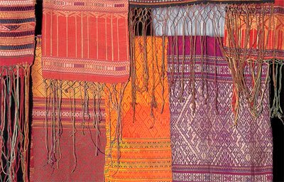
In the Phu Phan Mountain Range, at short distance to the northwest of Sakon Nakhon Town, the Phu Phan Royal Palace was constructed, known in Thai as Phra Tamnak Phu Phan Ratchatiwet. There, the Royal Family would reside during the dry season. In the surrounding area, several Royal Projects are being implemented, based on the findings of seminal research. They are geared to kindle and foster activities conducive to improving the livelihood of the local population. One such focus has been the revival of the traditional fabric weaving craft and artisanship. This venture has met with spectacular success, at local, regional, national and even international levels.
Among other ventures in mountain areas is the establishment of several Buddhist monasteries which have become recognized as retreats in several aspects. Their remoteness, natural surroundings, in some instances strenuous access, and rigour of monastic life create an environment focused on studies and meditation. An example is the monastery named Wat Pha Nam Thip Thep Prasit Wanaram in an area of 400 hectares, with its landmark, the Phra Maha Chedi Chai Mongkhon, situated on top of a big cliff called Pha Nam Yoi, also called Phuttha Utthayan Isan, in Roi Et Province. In the provincial capital, there in the monastery named Wat Nuea, the campus of the religious academic institution known in Thai as Maha Makut Ratcha Witthayalai, a university for monks, specializes in the teaching and studying of Buddhism in the Dvaravati Period. Also in Roi Et Province, there in the monastery known as Wat Burapha Phiram or Wat Hua Ro, stands the tallest Buddha statue of Thailand. Named Phra Phuttha Ratchamongkhon Maha Muni, or Luang Pho Yai, for short, the statue was built of steel-reinforced concrete. The statue itself is 59.2 metres tall; the entire structure is 67.85 metres high.
NATURAL RESOURCES AND PROTECTED AREAS
As the shifting of the sites of regional centres throughout history indicates, natural resources have always been unevenly distributed. While the headwater areas and their immediate upland settlements appear to have sufficient water, seasonal drought is severe in large parts of the lowlands. The forest cover has been greatly reduced, and forests might have been depleted, unless this threat had been averted by the demarcation of numerous nature reserves in mountain areas. Rock salt reserves appear to be huge. They have by far not been depleted over thousands of years. Industrial salt production, however, has caused hazards to the vegetation cover, in general, and to farming, in particular, as well as to freshwater fishing and aquaculture.
Major attractions of the natural environment are cliffs, waterfalls, floodplain as well as wetland forests, and lakes. The big cliff named Pha Nam Yoi in Roi Et Province, part of the Pha Nam Yoi National Park, also known as Phuttha Utthayan Isan, is given as an example. It rises up to 200 metres above the ground, with water seeping all year round. Out of the many waterfalls, one in Kalasin Province is called up. Named Tat Sung Waterfall, its torrents tumble across large rocks and through pools into a very large, rocky basin at its bottom, the largest of its kind in Thailand. Rare flood plain forests still exist in the Songkhram River Basin. Two types are distinguished. The forest called pa bung in the Thai vernacular of Isan grows in riverside land which turns into a marsh during the rainy season. Another type of forest, called pa tham in Isan, grows in low-lying areas with abundant water, in other words, in wetlands. These floodplain forests are the habitat of a rich diversity of rare, wild plant and animal species. The best known of the lakes and reservoirs, old and new, is Nong Han in Sakon Nakhon Province. It also is the largest freshwater lake in Thailand. The physical and geographical conditions literally invite the establishment of nature reserves. Some are small, owing to a distinctive biotope and ecotope, and some are large to the extent that they straddle parts of two or more provinces.
Examples of the category of small-size nature reserves are the Lam Pao Forest Wildlife Conservation Centre, also known as Suan Sa-on covering an area of 227 hectares, in Kalasin Province; the Pa Dun Lampan Forest No-hunting Zone covering an area of 144 hectares, and the Kosamphi Forest Reserve covering an area of 20 hectares, both located in Maha Sarakham Province; and the Pha Nam Yoi Forest Reserve in Roi Et Province, covering an area of 160 hectares, which is part of the large Pha Nam Yoi National Park. Five examples of the category of large-size nature reserves, which typically are called national parks, are briefly introduced hereunder. The Pha Nam Yoi National Park spreads across parts of Roi Et, Kalasin and Mukdahan provinces. Its area of 320 square kilometres is covered with mixed forest. The Phu Phan National Park with an area of 699 square kilometres covers parts of the three provinces of Sakon Nakhon, Nakhon Phanom and Kalasin, including a vast jungle. The Phu Pha Lek National Park straddles parts of Sakon Nakhon, Udon Thani and Kalasin provinces, totalling an area of 419 square kilometres. The Phu Pha Yon Chaloem Phrakiat National Park is the comparatively largest, with an area of 828 square kilometres across parts of Sakon Nakhon, Nakhon Phanom and Mukdahan provinces.
The Phu Sa Dok Bua National Park encompasses pristine forest in the border area of the three provinces of Yasothon, Mukdahan and Amnat Charoen. Few plant species of the natural vegetation are summarized, relying on the selection of obviously important species named in official documents, in which they are singled out as facets of the distinctive setting of any province. Rattan is named as a plant which thrives in the floodplain forests of Sakon Nakhon Province, where some 50 varieties grow. Several are identified such as wai khom or wai khok used for stringing, wai bon or wai krabong suitable for furniture-making, waihang nu and wai dong, both used for basket-making, and young shoots used for food preparation. As specialty of Maha Sarakham Province figures wild or bastard cardamom, called reo in Thai, which is valued for its essential oils containing fragrances such as borneol, camphor and linalool used to prepare herbal medicine. Thickets of assorted kinds of bamboo dot the nature reserves. The soil and climate are suitable for the growing of mulberry trees, on whose leaves the silkworms feed. This has literally spun off the burgeoning home-based silk producing, silk dying and silk weaving industries.
Forests are distinguished into several types. These are Dipterocarpus hardwood [ teng rang ] forest, virgin forest, virgin dry forest, dry mountain forest, and deciduous mixed forest. Forest trees identified are few. They include several trees of the Dipterocarpus genus, called yang in both Thai and English, Lagerstroemiaspp. [ tabaek ], Rubiaceae spp. [ krathum ], ironwood, and wild almond [Irvingia malayana (Simarubaceae) kabok ].
The samples of wildlife render, assembled and categorized, the following picture. There are monkeys such as langurs and large packs of golden gibbons. Other mammals include elephants, boars, civets, and hyenas. Of the species of ungulates there are rare red gaurs, barking deer, sambar deer, and mouse-deer or chevrotains. Siamese fireback, pea-fowl, and pheasants represent fowl. Among crustaceans is the rare crab species officially named pu thunkramom, in honour of H.R.H. Princess Chulabhorn.
ETHNIC DIVERSITY AND INDIGENOUS KNOWLEDGE
The present population of Isan has many roots. As highlighted in the descriptions of distinctive features of the provinces of Kalasin, Maha Sarakham, Roi Et, Sakon Nakhon and Yasothon, one of the assets with regard to development is the rich diversity of cultural traditions. It is officially considered as of great significance for local manufacturing industries, particularly for the One Tambon One Product (OTOP) project, and for the promotion of tourism.
Examples of such cultural traditions kept alive are villages of the Lao. They migrated in large numbers late in the Ayutthaya and early in the Rattanakosin periods, mainly from Champasak in present-day southern Laos. Their descendants form the majority of the population of Yasothon Province, and those who moved onward settled all over Roi Et Province.
Thai Yo, originally from Yunan, settled during the reign of King Rama III in Sakon Nakhon and Yasothon provinces. Communities of descendants of Phu Thai, whose ancestors had fled their homeland to the east of the Mekong River, had migrated from areas in present-day Laos and Vietnam, or else had been taken captive in Laos and settled in Isan, exist in several provinces. Some Phu Thai had come from Thaeng, now located in Vietnam, and settled in Kalasin Province such as the people who preserve their tradition at Mu Ban Watthanatham Phu Thai Khok Kong in Kut Wa Sub-district of Kuchinarai District, a venture initiated and promoted by the provincial administration as a tourist destination with home-stay accommodation.
Several Phu Thai communities in Sakon Nakhon Province trace their origin to hostages, known as Phu Thai Dam and Phu Thai Khao, taken captive upon the suppression of the rebellion by the Lao prince Chao Anuwong during the reign of King Rama III. These settlers are scattered throughout the Phu Pan Mountain Range. Another group of Phu Thai migrated from present-day Laos in 1843, during the reign of King Rama IV. Some others are descendants of refugees from the left bank of the Mekong River who were granted refuge more than 100 years ago. The Phu Thai communities in Yasothon Province descend from inhabitants of the historic area known as Wiang Chan, the present-day Vientiane, captured after the victorious military campaign of King Rama III.
While by far most descendants of the ancient Khmer population became assimilated into the mainstream population, there still are some locations where especially their oral tradition is upheld through the medium of their mother tongue. One example are the Khmer who are concentrated in the Phlapphla River Basin, whose northern part belongs to Roi Et Province, facing the southern part in Surin Province.
The ethnic group whose members call themselves Kui, in some instances transliterated as Gui, and mostly referred to as Suai, originally hails from the Boloven Plateau in present-day southern Laos. The Kui, who speak a language that belongs to the Austro-Asiatic group of Mon-Khmer, are renowned for their skill in rounding up wild elephants and tame them. Their alternative, external name of Suai, which they deem derogatory, refers to the annual tribute, suai in Thai, which they were obliged to deliver to the Crown. Within the geographical area described here as “Heartland of Isan”, groups of Kui live in Maha Sarakham and Roi Et Provinces, there along some tributaries of the Mun River.
Among the ethnic groups hailing from areas across the Mekong River is that of the So or Kha So. People of this stock are concentrated in Kusuman District of Sakon Nakhon Province. The ancestors of some had migrated from Maha Chai Kong Kaeo in present-day Laos, while those of others had been taken prisoners during the military campaigns successfully waged by King Rama III. In a local cultural centre, items of the So material culture are displayed and documents written in the So language preserved. As the need to have them translated into the Thai language proves, the language of the So differs substantially from the Thai and Lao languages.
People of Chinese ethnic origin almost typically are descendants of immigrants who had established themselves in Nakhon Ratchasima during the Third to Fifth Reigns, 1824-1910, and had mainly engaged in trading. Members of those Chinese families, then, moved onward to settle in towns and markets throughout the “Heartland of Isan”. As stated in a document published by the Office of the National Culture Commission, “all these ethnic groups are fully assimilated and consider themselves Thais.”
BUILDING PRODUCTIVE COMMUNITIES
Almost in the middle of Isan lies an expansive plain called Thung Kula Rong Hai. It is a harsh place to live in. While it is flooded during the rainy season, in much of this plain the water would quickly recede and completely evaporate, leaving the ground parched and scorched at the peak of the dry season. As an old folktale has it, wandering across this plain, thung in Thai, the people who make brooms and peddle them, kula, face hardship to the extent that they could not help crying, rong hai. Its area size of 3.372 square kilometres exceeds that of Rhode Island (3,100 sq km) in the United States. It covers parts of the six provinces of Buri Ram, Maha Sarakham, Roi Et, Si Sa Ket, Surin and Yasothon. One third of the area is located in Roi Et Province alone. Together with its parts in Maha Sarakham and Yasothon provinces, the largest proportion of the Thung Kula Rong Hai, which equals the area size of the Grand-Duchy of Luxemburg (2.586 sq km), a European country, is part of the “Heartland of Isan”.
In the course of implementing development projects, a large portion of this vast plain has become not only a productive area but also the land in which the unique Jasmine Rice, called khao hom mali in Thai, is grown. This rice variety is similar to the one known as basmati, its Hindu as well as Urdu name, which is grown in South Asia. Like this highly valued agricultural produce, other local products as well have gained high appreciation. They are typically manufactured by cottage industries. Examples are those processing or producing wood, bamboo, clay, and yarn. Under Royal Patronage of H.M. the Queen, local centres for the promotion of supplementary occupations were set up, called Sun Silapachip. Examples are the Sun Silapachip Ban Kut Na Kham in Charoen Sin District and the Sun Silapachip Ban Chan in Ban Muang District of Sakon Nakhon Province, where various crafts are upheld through skill training. H.M. the Queen has taken it upon herself to draw public attention to the cultural heritage of artisanship by promoting its products at national and international levels.
Working wood into utensils and decorative items is a skill for which villagers specializing in wood carving of Charoen Sin and Ban Muang districts in Sakon Nakhon Province are well known. The villages named Ban Na Samai and Ban Thung Nang Ok in Mueang District of Yasothon Province have artisans who create miniatures of animals and traditional houses as well as utensils from wood and bamboo. Using bamboo, the artisans at Ban Si Kaeo in Mueang District of Roi Et Province manufacture the wind instrument called khaen, one of the musical instruments characteristic of Isan. In the same province, there in Thawat Buri District, expert craftspeople manufacture the reed, a device on a loom resembling a comb and used to space warp yarn evenly, known as fuem in Thai. Home-based potteries in villages of Charoen Sin and Ban Muang districts of Sakon Nakhon Province are examples of a thriving local ceramics industry. The best-known home-made product is renowned fabric which is woven in all five provinces of the “Heartland of Isan”. In many instances, the whole process of growing the raw material, spinning yarn, extracting dye, dying yarn, and weaving cloth takes place in one and the same location. Also, to an increasing extent local people took to the tailoring of ready-to-wear, pret-a-porter dresses and accessories such as handbags. Two materials are commonly used, cotton and silk.
An example of upholding the indigenous knowledge required to extract natural resources for the production of dyes is set by the local experts at Ban Wa Mai in Akat Amnuai District of Sakon Nakhon Province. They make use of certain tree barks, leaves and blossoms to extract substances which are used as natural dyes for home-spun yarns. Cotton fabrics are woven in villages and towns throughout the region, in far too many places as to list them here. Examples are the Sun Silapachip Ban Chan in Ban Muang District of Sakon Nakhon Province and the Sun Hatthakam Phu Thai Nong Hang in Kuchinarai District of Kalasin Province, as well as the villages named Ban Huai Luem, a project site of the Royal Thai Government’s One Tambon One Product (OTOP) project in Thung Khao Luang District of Roi Et Province, Ban Wa Mai in Akat Amnuai District of Sakon Nakhon Province, and Ban Si Than in Pa Tio District of Yasothon Province. In all these locations, cotton fabric is also tailored into ready-to-wear, pret-a-porter garments, accessories such as handbags, or triangulated cushions, to name few end-of-the-line products. Silk is the eminently prominent product of the area. Skills, techniques and designs are preserved in locations with population groups practicing traditional know-how. There, centres ensure continuity and further refinement.
Leading examples are the Sun Silapachip Ban Kut Na Kham in Charoen Sin District and the Sun Silapachip Ban Chan in Ban Muang District, both in Sakon Nakhon Province, as well as the Sun Hatthakam Phu Thai Nong Hang in Kuchinarai District of Kalasin Province. Other locations where silk worms are reared, their cocoons processed, silk yarn spun and woven into fabric include Ban Wa Mai in Akat Amnuai District of Sakon Nakhon Province, Ban Phon in Kham Muang District of Kalasin Province, Tha Song Khon in Kosum Phisai District of Maha Sarakham Province, and Ban Wai Lum in Thawat Buri District as well as Ban Huai Luem, an OTOP project village, in Thung Khao Luang District of Roi Et Province. Ban Phon is famous for its phrae wa fabric with a woven design called mud mee that comes in fabulous variations of rhombic patterns also known as ikat. Traditionally, the so-called Thai Phuan patterns have featured hues of red only, created through the use of certain natural dyes. Nowadays, on demand yarn is dyed in all other colours as well. The weavers of Ban Wai Lum enjoy a fine reputation for the exquisite and colourful patterns of their silk fabric. In all these locations, home-based enterprises have expanded into the manufacturing of end-of-the-line products such as ready-to-wear, pret-a-porter silk garments and accessories. Especially the mud mee silk fabric in splendid patterns and colours symbolises the fascinating diversity of all that which is the “Heartland of Isan”.
Taken from: Thailand: Traits and Treasures. The National Identity Board, Royal Thai Government 2005.
Please note that we cannot take any responsibility for the correctness of the data shown on this Web site. We try our very best, but we depend on universities, their Web sites, and fellow students and lecturers, to get updates when ever programs, conditions, or tuition fees change.


 TOPOGRAPHICAL ORIENTATION
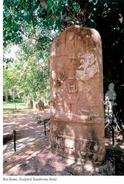 In 1987, people of Sakon Nakhon Province stalking game in the mountains named Phu Pha Yon discovered stone carvings at the sites of two caves. In front of the Phra Dan Raeng Cave, they found a 115 square metre-sized slab believed to have fallen off the cliff. Although damaged, the remains show images created by abrading and engraving. They are categorized as marks and symbols, geometric patterns, human body parts, animals including two fish, trees and boughs. Stone carvings found in a niche in the sandstone cliff at Pha Lai Cave are grouped as human beings, some lifelike, some semi-lifelike; animals, including a fish, dogs, a squirrel, buffaloes, cattle and frogs; geometric patterns; tools and utensils including a plough, a hoe and a fan; and two houses with a triangulated roof each. These stone carvings are deemed as of tremendous archaeological value. Some scholars surmise that these items of cave art are more than 3,500 years old, in all likelihood older than pre-historic symbolic images discovered in China and India. More of such prehistoric images were found at the Phak Nam Cave in the Phu Pha Lek and Huai Huat National Parks within Sakon Nakhon Province.
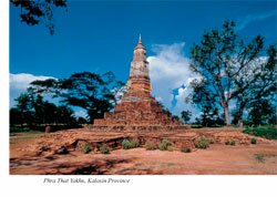 In the centre of this capital of a Dvaravati realm is the modest edifice of a monastery, Wat Pho Chai Semaram, which is surrounded by ancient sandstone stelae, bai sema, some of which are decorated with bas-relief. The finest was discovered in 1974. Its bas-relief shows a king and queen adoring the Buddha. The sheer number of stelae remaining in situ points to the wealth of artefacts coming from this ancient city surrounded by two rows of moats. The most complete ruin, also the tallest edifice of Mueang Fa Daet Song Yang, situated on a nearby hill, is Phra That Yakhu, a brick chedi, one of originally four pagodas built in the Dvaravati Period on the hills called Non Fa Yat and Non Fa Daet. Of the original pagoda only the star-shaped base decorated with some remaining traces of stucco has been preserved unchanged. During the Ayutthaya Period, an octagonal chedi was built on the original base, and during the Rattanakosin Period the top was raised.
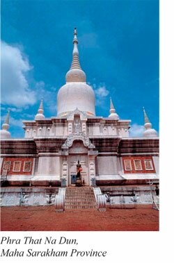 rear sides of these Buddha images bear inscriptions, one 11.2 by 13.8 and the other 4.2 by 3.8 centimetres, both written in Pallawa letters used in the 6th to 7th centuries. Soon, villagers brought many more items such as stupa fragments and a compact containing relics of the Buddha. Eventually all led to the reconstruction of the religious edifice and its consecration in 1987.
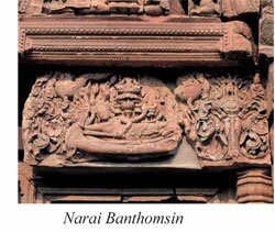 Ku Phra Ko Na is a Khmer site with three brick pagodas on a single base, surrounded by a wall and gateways, all built of sandstone in the Baphuon style during the 11th century. There is a gap of a missing lintel as well as traces of a Naga bridge and covered walkway leading to the outside pond, or barai in Khmer language, nearby. The lintel was removed to an unknown destination. The site of Prang Ku, also known as Prasat Nong Ku, is an example of an ancient hospital and infirmary built in the 13th century and characteristic of the Khmer Empire since the reign of King Jayavarman VII (1181-1220). Although referred to as “hospital” in the literature, such centres served as infirmary as well. The ruins of Prang Ku comprise of its main tower, gateway, wall, and pond outside the wall. The artefacts displayed on-site include a sandstone lintel that was once above the doorway of the main tower, door colonettes and the lotus-shaped finial of the tower. As stated in an inscription, it was one of a group of buildings called arokhayasala, hospital and infirmary ward.
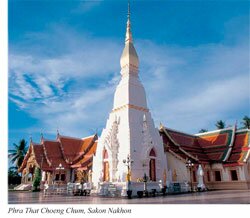 In similar fashion, the site of Sakon Nakhon Town, abandoned after a severe drought, was resettled and renamed Chiang Mai Nong Han, also known as Mueang Nong Han Luang. In present Sakon Nakhon Town, the existing monastery named Wat Phra That Choeng Chum, in the belief of the faithful highly revered as the site which the Lord Buddha visited to bless the townspeople, as proven by four footprints of the Lord Buddha of four incarnations, and venerated as a source of civilization for thousands of years, was built on the site of an older sanctuary. The Lan Chang-style, 24-metre tall chedi named Phra That Choeng Chum was built on the remains of an old stupa. The chedi has a square base and three indented tiers, with a tapering finial decorated with square-shaped lotuses and a gilded parasol at the top. The three entrances to the north, south and west disclose the old stupa inside; on each door arch stands a Buddha image in the Lan Na style.
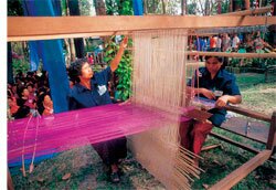 In the Phu Phan Mountain Range, at short distance to the northwest of Sakon Nakhon Town, the Phu Phan Royal Palace was constructed, known in Thai as Phra Tamnak Phu Phan Ratchatiwet. There, the Royal Family would reside during the dry season. In the surrounding area, several Royal Projects are being implemented, based on the findings of seminal research. They are geared to kindle and foster activities conducive to improving the livelihood of the local population. One such focus has been the revival of the traditional fabric weaving craft and artisanship. This venture has met with spectacular success, at local, regional, national and even international levels.
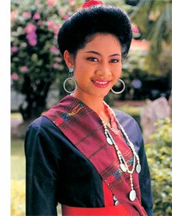 The present population of Isan has many roots. As highlighted in the descriptions of distinctive features of the provinces of Kalasin, Maha Sarakham, Roi Et, Sakon Nakhon and Yasothon, one of the assets with regard to development is the rich diversity of cultural traditions. It is officially considered as of great significance for local manufacturing industries, particularly for the One Tambon One Product (OTOP) project, and for the promotion of tourism.
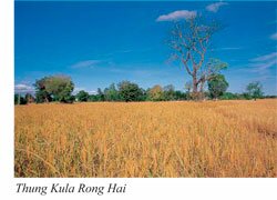 Almost in the middle of Isan lies an expansive plain called Thung Kula Rong Hai. It is a harsh place to live in. While it is flooded during the rainy season, in much of this plain the water would quickly recede and completely evaporate, leaving the ground parched and scorched at the peak of the dry season. As an old folktale has it, wandering across this plain, thung in Thai, the people who make brooms and peddle them, kula, face hardship to the extent that they could not help crying, rong hai. Its area size of 3.372 square kilometres exceeds that of Rhode Island (3,100 sq km) in the United States. It covers parts of the six provinces of Buri Ram, Maha Sarakham, Roi Et, Si Sa Ket, Surin and Yasothon. One third of the area is located in Roi Et Province alone. Together with its parts in Maha Sarakham and Yasothon provinces, the largest proportion of the Thung Kula Rong Hai, which equals the area size of the Grand-Duchy of Luxemburg (2.586 sq km), a European country, is part of the “Heartland of Isan”.
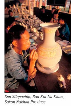 Working wood into utensils and decorative items is a skill for which villagers specializing in wood carving of Charoen Sin and Ban Muang districts in Sakon Nakhon Province are well known. The villages named Ban Na Samai and Ban Thung Nang Ok in Mueang District of Yasothon Province have artisans who create miniatures of animals and traditional houses as well as utensils from wood and bamboo. Using bamboo, the artisans at Ban Si Kaeo in Mueang District of Roi Et Province manufacture the wind instrument called khaen, one of the musical instruments characteristic of Isan. In the same province, there in Thawat Buri District, expert craftspeople manufacture the reed, a device on a loom resembling a comb and used to space warp yarn evenly, known as fuem in Thai. Home-based potteries in villages of Charoen Sin and Ban Muang districts of Sakon Nakhon Province are examples of a thriving local ceramics industry. The best-known home-made product is renowned fabric which is woven in all five provinces of the “Heartland of Isan”. In many instances, the whole process of growing the raw material, spinning yarn, extracting dye, dying yarn, and weaving cloth takes place in one and the same location. Also, to an increasing extent local people took to the tailoring of ready-to-wear, pret-a-porter dresses and accessories such as handbags. Two materials are commonly used, cotton and silk.